


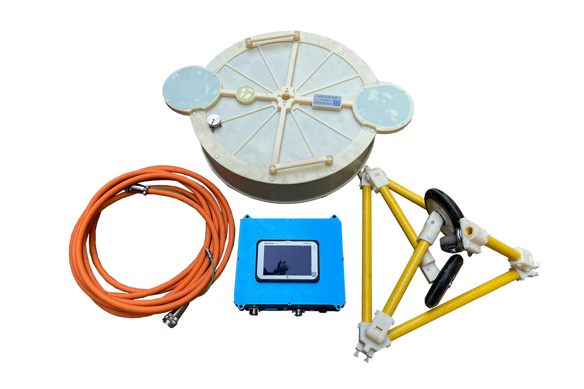
WuKong DTEM(drone airborne TEM systems)
Product introduction
WuKong DTEM system is the first transient electromagnetic (TEM) system by drone for large depth geological survey all of the world, which is developed by Triloop Prospecting Co., Ltd. WuKong DTEM system adopts high-speed linear turn-off, lossless decoupling technology and other proprietary technologies, realizes the transmit magnetic moment up to 34,000 Am2@70A, takes into account both large depth prospecting and shallow surface prospecting without blind area. its depth of prospecting is 2-400m using continuous measuring and 2-700 meters using hovering point measuring, and could flexibly select the transmitting and receiving coil (diameter 2-10 m) according to the requirements of prospecting. WuKong DTEM has many advantages, such as high efficiency, free from terrain restrictions, high safety, short operation preparation time, convenient transfer, and low cost, because transmitting and receiving system adopts lightweight integrated design and takes large-load multi-rotor UAV as the carrier. It could be widely applied in complex terrain in mountainous areas, water areas, swamp, both upstream and downstream face of dam, coal mine goaf, and disaster emergency……


· flexible and convenient
With unique detachable component design, the coil could be installed on site, and the preparation time of the whole system is less than 0.5 hour. Relatively flat open space can be used as a take-off point, without the need for an airport.
· Extremely high efficient data processing
WuKong DTEM system adopts Triloop cloud αTEM remote supercomputer platform. Triloop cloud αTEM supports remote real-time imaging, 3D fast imaging, realizes data cloud synchronization and sharing, has features such as high man-machine interaction, controllable computing mode, extremely fast computing speed(inversion of 100 survey points cloud be accomplish in 5 seconds).

So far, we have carried out engineering technical services for several projects, such as golf survey of coal mine burning area, geological survey of pumped storage power station, exploration of paleochannel sandbody, survey of silt layer and dam root stone in Yellow River, seepage detection of South-to-North Water diversion dam, geological survey of groundwater (karst cave), detection of unidentified buried objects (UXO) in Brunei port area.
· transmit magnetic momen:34,000 Am2@70A (diameter 7m) prospecting depth: 2~400m using continuous measuring2~700 meters using hovering point measuring
· transmit magnetic momen:70,000 Am2@70A (diameter 8.6m)prospecting depth: 2~600m using continuous measuring2~1000 meters using hovering point measuring
· Endurance time of UAV: 1~1.5h
No.1 Quick investigation of dike’s hidden danger in Jiangxi Provinc
 |
Fig1. inversion result of drone ATEM in dam detection (depth=-22m)e |
WuKong DTEM has successfully detected the potential danger of the dam upstream face, and has the advantages of fast, high precision and full region detection. |


No 2 Detection of unidentified buried objects (UXO) in Brunei port area
 |
Fig3. the result of drone ATEM (depth=-2.0m) |
Sixty effective anomalies were detected, eliminating potential safety hazards of unexploded ordnance, ensuring the safety of port construction, and promoting the smooth implementation of Belt and Road Initiative Project. |


No.3 karst investigation in Wanyuan City, Sichuan Province
 |
Fig4 inversion profile of WuKong DTEM Three karst areas were detected and verified in the project construction. |

No4. golf survey of coal mine burning area in Xinjiang Uygur Autonomous Region
|
The spatial distribution and scale of geophysical anomaly of coal seam goaf within 200 depth below the surface were obtained. |
 |

No.5 exploration of paleochannel sandbody in Inner Mongolia Autonomous Region
 |
 |
No6. geological survey of pumped storage power station in Guangxi Zhuang Autonomous Region
 |
 |
In rugged topography, WuKong could achieve the same effect on fault resolution as the surface method


